Forum
Warto wiedzieć
Twoje Forum
Forum Giełda
+Dodaj wątek
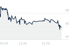
Opublikowano przy kursie:
102,50 zł
, zmiana od tamtej pory:
-4,39%
My tu skupieni na sektorze prywatnym (banki, amazon itp)
Zgłoś do moderatoraa w 2024, ponad 40% przychodów było w naszej perle z sektora publicznego. Nie mawiąc o nowych use-casach które opublikowali
na swojej stronie w temacie łączenia danych satelitarnych i innych w celu monitorowania bezpieczeństwa na wodzie w kontekście sabotaży, floty cieni, dronów. W tym papierze opis jest w czasie przeszłym co oznacza nowe use-case'y już przetestowane w bardzo gorącym temacie
Use Case 1 – AIS Dark Activities
Automatic Identification System transponders broadcast a vessel’s location, identity and speed. When a vessel stops transmitting AIS for more than 20 minutes—outside natural radio dead zones—it is considered to be conducting dark activities. In July 2025, analysts detected 125 vessels going dark for more than 30 minutes within a single day on a busy sea route (not all necessarily malicious). DataWalk can record the last known AIS packet’s time and location, then flag any extended gaps where other ships in the same geohash area continue to transmit. Analysts can cross‑reference these gaps with GNSS jamming data, port logs or sensitive infrastructure polygons to assess whether the dark zone corresponds to suspicious behavior, such as a vessel meeting another ship or loitering near undersea cables. By fusing AIS time series with satellite imagery and knowledge graphs, DataWalk reveals patterns that flat indexing would miss.
Use Case 2 – Vessel Identity Verification (MAID)
Criminal or state actors may use fraudulent transponders registered to other ships to conceal a vessel’s true identity. In one scenario, a cargo ship claimed to sail under the Cypriot flag but may have been a Russian spy vessel. Analysts used DataWalk to search Maritime Mobile Service Identity (MMSI) datasets and automatically download Mobile Advertising Identifier logs (MAIDs) for the Baltic Sea. By creating geospatial and temporal filters on a map, they selected 147 MAID logs representing 16 unique devices and ran a DataWalk application to check where those IDs had been recorded in the past two weeks. Twelve devices had previously been logged in Russia and four in a military base in the Kaliningrad area. This cross‑correlation of MAIDs, AIS logs and geopolitical information highlights how DataWalk’s knowledge graph surfaces discrepancies between declared and actual vessel identities.
Additional verification comes from comparing vessel dimensions estimated via SAR imagery with the dimensions declared in AIS. Deviations greater than ±10–15% in length or beam are strong indicators that the transmitting identity does not match the observed vessel.
Use Case 3 – Vessel Beneficial Ownership Analysis
Vessels involved in sabotage or sanctions evasion often sail under a flag of convenience. A ship may be registered to a company in Cyprus but actually controlled by a Russian entity through complex ownership chains. With DataWalk, analysts can run a visual, no-code query or use a natural‑language interface (e.g., Librechat) to find the beneficial owner of a vessel. When investigating a ship called Sunnyside Gas, the platform reported that it was owned by a Cyprus‑registered company. Further analysis revealed that the company was ultimately controlled by individuals of Russian nationality. DataWalk’s link‑chart visualisation displayed connections between shipping companies, holding firms and beneficial owners, enabling analysts to identify vessels that might be used for covert operations or sanctions evasion.
Use Case 4 – Vessel Profile and Situational Awareness Monitoring
For sustained situational awareness, agencies need to monitor vessel behavior over time. Analysts can select a region—such as the Bornholm Basin in the Baltic Sea—and apply filters on AIS data to identify vessels present in a given period. For example, in one case, 34 vessels were identified, and by overlaying polygons representing points of interest (e.g., critical undersea cables) plus a 2–3 kilometer buffer, DataWalk narrowed the list to vessels that came close to critical infrastructure. Next, analysts cross‑checked GPS jamming incidents in the same geohash and timeframe, discovering whether dark zones aligned with reported jamming events. In one case, a Cyprus‑flagged vessel was detected near the Baltic Sea cable polygon during a period of GPS interference, while a Russian‑affiliated ship was identified as responsible for a nearby jamming event. Such correlation across multiple datasets allows analysts to prioritize inspections and produce evidence for legal or diplomatic action.

- Kurs Euro
- Kurs dolar
- Kurs frank
- Kurs funt
- Wiron
- Przelicznik walut
- Kantor internetowy
- Kalkulator wynagrodzeń
- Umowa zlecenie
- Kredyt na mieszkanie
- Kredyt na samochód
- Kalkulator kredytowy
- Revolut
- Winiety
- Jak grać na giełdzie?
- Jak wziąć kredyt hipoteczny?
- Rejestracja samochodu
- Jak rozwiązać umowę z Orange
- Koszty uzyskania przychodów
- Sesje elixir
- PB weekend
- RRSO co to jest?
- Blogbank.pl
- Promocje bankowe - zgarnijpremie.pl
- Stopa procentowa